TomTom Go Mobile Vs Google Navigation
The smartphone is not only a gadget, it’s a sponge soaking up other gadgets around it. Then, in a way a sponge cannot, it takes on their function, leaving whole ranges of products obsolete and their makers dazed and confused.
The smartphone is a gadget sponge, mopping up and absorbing others, one at a time...
The satnav has been in its sights for a few years now and Google Navigation has been my primary runner for a while. The hardware market has responded by getting ever cheaper (but who can compete with free?) with occasional flashes of innovation. For example the latest Garmin incorporates a dashcam. Dashcams are a neat solution, but surely another gadget that the smartphone will likely emulate just as well before too long?
Earlier in the year, TomTom relaunched with an all new version of their smartphone app and an equally new payment model based on subscription. For £15 per year, or £35 for three years you get all of the services provided by their best hardware - which seems like pretty good value. But can TomTom Go Mobile compete with Google’s free Navigation service? I took to the road to find out.
Getting Started
When it comes to convenience, you want to be able to drop a satnav into a mount and get going just as soon as possible. Unless you want your phone’s battery to take a complete hammering, it’s a good idea to connect the phone up to some power.


On a typical day, I don’t even have to start Google Navigation before I start driving. At any point, I can just say “OK Google” and then “Navigate to X” and the phone will do the rest. X can be ‘Work’, or ‘Home’ or a postcode or city. By using the voice, Google will automatically select the best route based on current traffic conditions and start the 3D map (entering by hand will show you a few routes to consider). For the daily commute, it’s hard to beat this level of ease, at least if you have an Android phone.
TomTom on the other hand is a little bit slower off the mark. When navigating to a contact, you can set TomTom to be default sat-nav. Otherwise you need to fire up the app, which takes about 10 seconds to load on my Samsung Note 3, enter the menu and then use the touchscreen to set-up your journey.
Getting home from anywhere is pretty simple, as ‘Drive Home’ gets its own button. Equally you have ‘Recent Destinations’ and ‘My Places’ for saving your locations for quickness later. Using a smartphone to enter destinations is easier than any sat-nav I’ve ever used.
Navigation, Voice and Visual Guidance
When they first became popular (windscreen mounted sat-navs started around £400 ten years ago!) the news was full of horror stories about people driving into fields, rivers, off cliffs etc blindingly following the 3D maps. Whilst these incidents were surely overstated, I do remember several occasions where mine took me off a nice A road, down some single track B road where I was reduced to 20mph and then back onto the very same A road a few miles later!
Thankfully the algorithms have massively improved since then, helped by the mobile internet connection and real-time traffic flow information. In my tests, only very occasionally was I dealt a strange instruction where a shortcut that might look good on paper would never have worked out so well in real life.
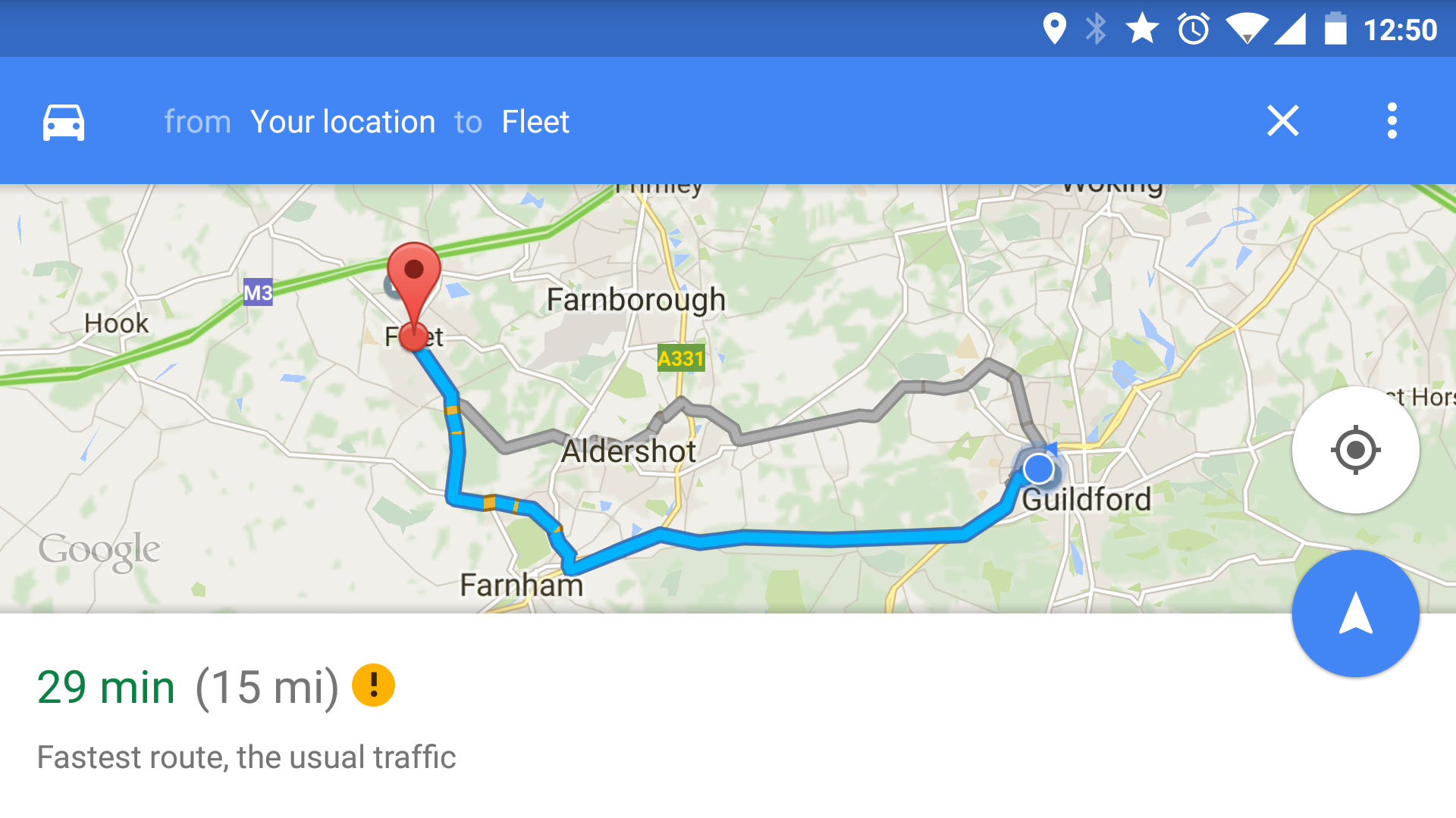
When typing a destination into Google, you’ll be shown three different options on a map to follow, each with distance and estimated journey time. This is handy because you may not wish to travel an extra 10 miles to save 3 minutes and a single tap kicks off your preferred route.
TomTom approaches things slightly differently. By default it will always give you the fastest route and it’s up to you to ask for an alternative. In the settings however, you can change the priority to shortest instead, or even the most eco-friendly.
Whilst Google seems more flexible here, I always found TomTom’s navigation choices to be excellent and it’s quick to reroute if you miss a turn or think you know better.


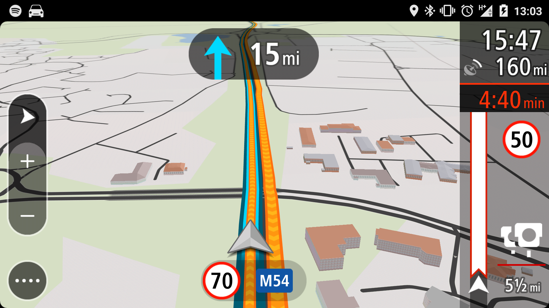
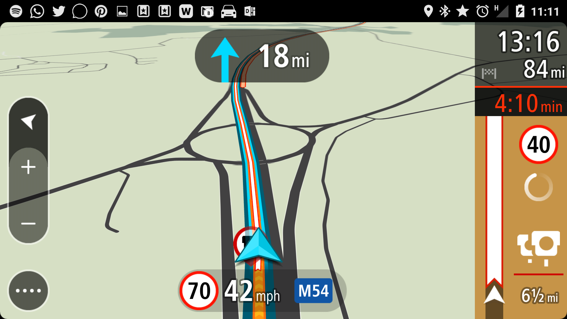
When it comes to following instructions, both apps again put in a good show. On balance, I’d say the TomTom (above, right) is providing a richer set of information. The 3D map itself is the same bold cartoon like set of graphics that owners of TomTom devices will be well used to. At the bottom of the screen, you’ll find the current speed limit, which I found to be accurate about 90% of the time. It even picked up roadwork's reduced speed limits regularly. Whilst you should probably rely on signs for this first, it’s a handy helper when you’re not sure.
On the right hand side of the screen is where you’ll find all the traffic information related to your journey. An estimated arrival time along with miles remaining sits at the top and underneath a line showing around 20 miles ahead shows upcoming slowdowns, lane closures, accidents and speed cameras, giving you plenty of time to prepare. Cameras, once they’re close will cause an alert to sound and if they’re mobile ones, TomTom will ask you if the camera was present. If you see a camera that you weren't warned about, you can report it in the TomTom menu, but I recommend this being a job for passengers unless you’re stationary. Too many button presses for a moving vehicle.
If a faster route becomes viable, then TomTom will suggest it - but I rather prefer Google’s methods here. As you drive along, Google will show you on approach to junctions how much longer or shorter the journey will be if you are to take it. This I’ve found to be so useful on my commute that it’s changed the way I use sat-navs. Originally I only took mine out for new journeys, but for the past year or so I’ve used Google every day. The traffic can be so changeable on my horrible commute, that several times I’ve noticed a junction will save me 20 minutes or so allowing me to avoid slowdowns caused by traffic jams, accidents etc. On the way home there is a choice for me to stick to motorway or head into the countryside. Usually the difference is only a few minutes, but every now and then it’s greater and having this information at a glance means I feel like I have a bit of an advantage.
That said, on longer journeys, like a recent trip to Snowdonia in North Wales, the information TomTom gave me on delay times and why there were delays was eerily good and definitely contributed to keeping frustration down at some of the truly awful traffic I had to get through. For example, one very nice touch is when travelling along a motorway with an average speed limit, TomTom will tell you what that limit is and what your average speed is running at.
Both TomTom and Google’s voice and turn instructions are given in good time, with lane advice and next turn information being extra helpful at complicated junctions. TomTom had the edge when pronouncing road names, but I never struggled with either. If pushed, I would say I prefered TomTom's which had a little more fidelity and also faded the music coming from my Spotify app rather than briefly pausing it, which is what Google does.
The only real frustration with Google is that the alternative route times would sometimes disappear just as I needed them when the camera zoomed in to give a close up of the junction and my currently planned route. I’d then take the turn and see the alternative too late saying I could have saved 5 minutes. I think these need to be displayed earlier.
No Internet - No problem?
A good mobile signal is a bit of a gamble round here...
The internet helped improve the quality of our navigation devices in two ways. Firstly, traffic conditions could be shared with them to ensure the best route is selected. Roadside sensors and smartphones relaying position and speed mean that this information can be handled in real-time. Secondly, sat-navs and smartphones can connect to much more powerful servers in the cloud that do all the heavy lifting and then pass back the instructions to be delivered to us drivers.
oh pants....
Google Navigation makes full use of this power, but there is a problem. The internet is not always there, particularly when you’re driving around the country. The 90% coverage your mobile provider claims is about people, not geography and there are vast areas with no signal at all.
Take my trip to Snowdonia for example. I was actually pleasantly surprised that my mobile nearly always had a signal, but the data rate was of the basic ‘G’ variety 95% of the time. That renders an awful lot of the internet useless, including Google Navigation. You’ll need at least a 3G signal to get started, although once up and running, the app can deal with signal outages just fine. Take a wrong turn in the middle of no where and prepare for frustration as the ‘Rerouting’ comes up and patiently waits for a signal that may never come.
TomTom on the other hand, has no such limitation. You see the maps are all downloaded to your phone and all the features except traffic information are available all the time. The caveat to this is that you have the space available on the phone to hold the large files. The UK map for example weighs in at 700 MB. You don’t want to be downloading that over a mobile connection particularly, so best to grab over WIFI before you go. I also noted that when a map update is released, you have to download the whole 700MB again.
It’s probably the approach to storing and navigating the maps that is the single biggest differentiator between the products. Certainly for me, on holiday I’m so glad I took the TomTom app. Travelling abroad too, I’d definitely be happy to add £15 to the holiday budget and not rely on potentially patchy and expensive mobile data connections to get around.
Daily weekday use for about 1.5hrs sees maps use about 200MB per month in my case
If you have a basic phone with limited storage, you may have also elected to keep the cost down by limiting your monthly data allowance. The good news is that Google Navigation doesn’t use as much data as you might imagine. Setup the journey over WIFI before you leave the house will see it only sip at the connection for traffic information, but even if you don’t, I’m finding my 40 miles a day commute uses up 200MB per month - which may give you a clue as to how much you might use.
Verdict
The end could be in sight for the dedicated sat-nav, but TomTom have responded well
In the face of tough competition TomTom has shown that it can see and move with disruptive change to its traditional business and it has developed an excellent sat-nav app for a very reasonable price. Running on a big smartphone like my Samsung Note 3, it provides an all round better experience than I previously enjoyed on a £250 TomTom Go device. If you spend £35 and get three years, you’ll come out the other side having spent less than half the money of a cheap entry level dedicated unit and you’ll have always enjoyed the very latest maps and innovations.
So should you buy TomTom over Google? Well, if you have an iPhone I would say yes. Android owners have a trickier choice, because Navigation is baked so well into the phone already. Searching for a business in Google Chrome for example will give you a single button in the results to have Navigation take you there - it will even warn you if the business might not be open!
As a daily commuter tool, I will continue to use Google - but on holiday, the TomTom was definitely the preferred app, particularly because of its offline maps, but also the traffic information was just that bit more advanced on screen. I’ll continue to use it for long unfamiliar journeys.
At the end of the day, it’ll be different strokes for different folks, but the good news is, TomTom will give you 50 miles of navigation for free per month. This is definitely worth having to get you out of a hole if you can afford the space on your phone and then you can see for yourself if it’s worth buying a license and help keep the TomTom brand alive. Something I think they've earned.